Darmstadt-Dieburg
Darmstadt-Dieburg | |
|---|---|
District | |
 | |
| Country | |
| State | Hesse |
| Adm. region | Darmstadt |
| Capital | Darmstadt |
| Area | |
| • Total | 658.51 km2 (254.25 sq mi) |
| Population (31 December 2017)[1] | |
| • Total | 296,048 |
| • Density | 450/km2 (1,200/sq mi) |
| Time zone | UTC+01:00 (CET) |
| • Summer (DST) | UTC+02:00 (CEST) |
| Vehicle registration | DA, DI |
| Website | http://www.ladadi.de |
Darmstadt-Dieburg is a Kreis (district) in the south of Hesse, Germany. Neighboring districts are Offenbach, Aschaffenburg, Miltenberg, Odenwaldkreis, Bergstraße, Groß-Gerau, and the district-free city of Darmstadt, which it surrounds.
Contents
1 History
2 Geography
3 Coat of arms
4 Towns and municipalities
5 References
6 External links
History
The district was created in 1975 by merging the previous districts of Darmstadt and Dieburg. In 1963 the district was twinned with the district of North East Derbyshire, England, in 1990 with the district Zwickauer Land in Saxony, Germany, and in 1995 with the Mladá Boleslav region in the Czech Republic.
Geography
The district is located in the Odenwald mountains. Most famous in the district is the Messel Pit, where many fossils in the oil shale of a Tertiary lake were found. The site is listed in the UNESCO world heritage list since 1995.
Coat of arms
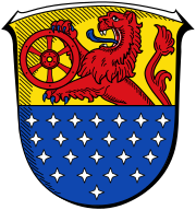 | The coat of arms show a lion in the top part, taken from the coat of arms of the counts of Katzenelnbogen. The lion holds a Wheel of Mainz, the symbol of state of Mainz. Both owned big parts of the districts area in the past. The 23 stars in the bottom represent the municipalities of the county. |
Towns and municipalities
| Towns | Municipalities | |
|---|---|---|
|
|
|
References
^ "Bevölkerung der hessischen Gemeinden". Hessisches Statistisches Landesamt (in German). September 2018..mw-parser-output cite.citation{font-style:inherit}.mw-parser-output q{quotes:"""""""'""'"}.mw-parser-output code.cs1-code{color:inherit;background:inherit;border:inherit;padding:inherit}.mw-parser-output .cs1-lock-free a{background:url("//upload.wikimedia.org/wikipedia/commons/thumb/6/65/Lock-green.svg/9px-Lock-green.svg.png")no-repeat;background-position:right .1em center}.mw-parser-output .cs1-lock-limited a,.mw-parser-output .cs1-lock-registration a{background:url("//upload.wikimedia.org/wikipedia/commons/thumb/d/d6/Lock-gray-alt-2.svg/9px-Lock-gray-alt-2.svg.png")no-repeat;background-position:right .1em center}.mw-parser-output .cs1-lock-subscription a{background:url("//upload.wikimedia.org/wikipedia/commons/thumb/a/aa/Lock-red-alt-2.svg/9px-Lock-red-alt-2.svg.png")no-repeat;background-position:right .1em center}.mw-parser-output .cs1-subscription,.mw-parser-output .cs1-registration{color:#555}.mw-parser-output .cs1-subscription span,.mw-parser-output .cs1-registration span{border-bottom:1px dotted;cursor:help}.mw-parser-output .cs1-hidden-error{display:none;font-size:100%}.mw-parser-output .cs1-visible-error{font-size:100%}.mw-parser-output .cs1-subscription,.mw-parser-output .cs1-registration,.mw-parser-output .cs1-format{font-size:95%}.mw-parser-output .cs1-kern-left,.mw-parser-output .cs1-kern-wl-left{padding-left:0.2em}.mw-parser-output .cs1-kern-right,.mw-parser-output .cs1-kern-wl-right{padding-right:0.2em}
External links
| Wikimedia Commons has media related to Landkreis Darmstadt-Dieburg. |
Official website
| Urban districts |
|
|---|---|
| Rural districts |
|
Coordinates: 49°53′55″N 8°40′32″E / 49.898498°N 8.675487°E / 49.898498; 8.675487
Authority control |
|
|---|


