Port Hacking
| Port Hacking Deeban[1] | |
|---|---|
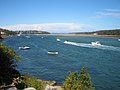
 Looking inland over Port Hacking estuary towards the west from the Tasman Sea. | |
 Port Hacking Location of Port Hacking in New South Wales | |
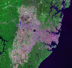 Port Hacking, the southern–most inlet shown on a 2005 NASA image of the urban sprawl of Greater Sydney | |
| Location | Southern Sydney, New South Wales |
| Coordinates | 34°03′55″S 151°08′05″E / 34.06528°S 151.13472°E / -34.06528; 151.13472Coordinates: 34°03′55″S 151°08′05″E / 34.06528°S 151.13472°E / -34.06528; 151.13472[2] |
| Type | An open youthful tide dominated, drowned valley estuary[3] |
| Etymology | in honour of Henry Hacking, a pilot at Port Jackson[1] |
| Primary inflows | Hacking River |
| Primary outflows | Tasman Sea |
| Catchment area | 165.3 km2 (63.8 sq mi) |
Basin countries | Australia |
| Managing agency | Sutherland Shire Council, |
| Surface area | 11.7 km2 (4.5 sq mi) |
| Average depth | 9.1 m (30 ft) |
| Water volume | 105,261.5 km3 (8.53369×10¹⁰ acre⋅ft) |
| Frozen | never |
| Settlements | Bundeena, Cronulla, Woolooware, Burraneer, Caringbah South, Dolans Bay, Port Hacking, Lilli Pilli, Yowie Bay, Miranda, Gymea Bay, Grays Point |
| Website | NSW Environment and Heritage webpage |
Port Hacking (Aboriginal Tharawal language: Deeban[1]), an open youthful tide dominated, drowned valley estuary,[3] is located in southern Sydney, New South Wales, Australia[4] approximately 30 kilometres (19 mi) south of Sydney central business district. Port Hacking has its source in the upper reaches of the Hacking River south of Helensburgh, and several smaller creeks, including South West Arm, Bundeena Creek and The Basin and flows generally to the east before reaching its mouth, the Tasman Sea, south of Cronulla and north–east of Bundeena. Its tidal effect is terminated at the weir at Audley, in the Royal National Park. The lower estuary features a substantial marine delta, which over time has prograded upstream. There is also a substantial fluvial (riverine delta) of the Hacking River at Grays Point. The two deltas are separated by a deep basin.
The total catchment area of Port Hacking is approximately 165 square kilometres (64 sq mi) and the area surrounding the estuary is generally managed by Sutherland Shire Council. While the area to the north of Port Hacking is urbanised, the area to the south is relatively pristine and forms the northern boundary of the Royal National Park.
The land adjacent to Port Hacking was occupied for many thousands of years by the Tharawal and Eora Aboriginal peoples and their associated clans. They used the bay as an important source of food and a place for trade.
Contents
1 History
1.1 Aboriginal history
1.2 European history
2 Description
3 Gallery
4 References
5 External links
History
Aboriginal history
For more than 8,000 years prior to 1840, the Tharawal (or Dharwal) people occupied the catchment area evidenced by hundreds of Aboriginal artefacts, middens, rock carvings and cave paintings. In the mid 19th century shell grit was in high demand as a source of lime for building in the Sydney district. Consequently, mud and oyster rocks were collected in large numbers from Port Hacking catchment destroying a number of aboriginal midden sites in the region.[5]
European history
Matthew Flinders and George Bass (with Bass's servant William "The Boy" Martin) explored there in early April 1796. They called it Port Hacking after Henry Hacking who was the principal game hunter in the colony and who first told them of a large river he had seen inland on kangaroo hunting expeditions.[6][7] Hacking was the quartermaster on HMS Sirius, part of the First Fleet under the command of Governor Arthur Phillip. Hacking became a skilled, adventurous bushman, who led many hunting expeditions to supplement meat rations for Australia’s first settlers. He was amongst the party that found the lost government cattle at Cowpastures in 1795.[citation needed] He was also the man who in 1802 killed Pemulwuy an Aboriginal resistance fighter and a Bediagal man who had killed and harassed settlers and who since 1790 had been a wanted man.
European impacts have been substantial: the river has been effectively dammed at Audley, the dynamics of the frontal part of the marine delta were substantially altered by the creation of a fish hatchery at The Basin, shell grit extraction decimated large seagrass beds, and the entire northern shore is urbanised.
Port Hacking has been closed to commercial fishing for about a century, and there are other catch/harvesting closures throughout the Port.
The northern headland, located at Cronulla is called Bass and Flinders Point.
Description
Port Hacking effectively forms the southern boundary of Sydney's suburban sprawl. Working inland from the sea, the indented north bank of Port Hacking is formed by the suburbs of Cronulla, Woolooware, Burraneer, Caringbah South, Dolans Bay, Port Hacking, Lilli Pilli, Yowie Bay, Miranda, Gymea Bay and Grays Point. The southern bank is largely undeveloped land within the Royal National Park, although the small communities of Bundeena and Maianbar are found there. Warumbul and Gundamaian are other localities on the southern bank, in the Royal National Park. Cronulla and National Park Ferry Cruises operates a regular passenger ferry service that crosses Port Hacking, connecting Cronulla and its railway station to Bundeena. They also operate cruises along Port Hacking that depart from Cronulla.
Port Hacking is a drowned river valley, with a water surface area of 11 square kilometres (4.2 sq mi). With very little industrial and minor agricultural inputs via the Hacking River, the water quality is categorised as 'extremely good', and the extensive inter-tidal shoals provide opportunity for wading birds.[8]
Port Hacking is a popular recreational area, where many activities can be enjoyed such as swimming, fishing and boating. The estuary and bays are used for watersports such as wakeboarding and water skiing and Scuba driving. The distinctive shore feature, Shiprock, sits above the only aquatic reserve in Port Hacking. It has been protected because of the unique micro environment of marine fauna and flora.
Gallery
Port Hacking estuary near Burraneer
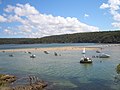
Port Hacking estuary at Lilli Pilli
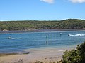
Port Hacking estuary at Lilli Pilli

Port Hacking estuary near Warumbul
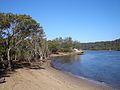
Port Hacking estuary at Grays Point


References
^ abc "Port Hacking (Bay)". Geographical Names Register (GNR) of NSW. Geographical Names Board of New South Wales. Retrieved 8 January 2013..mw-parser-output cite.citation{font-style:inherit}.mw-parser-output .citation q{quotes:"""""""'""'"}.mw-parser-output .citation .cs1-lock-free a{background:url("//upload.wikimedia.org/wikipedia/commons/thumb/6/65/Lock-green.svg/9px-Lock-green.svg.png")no-repeat;background-position:right .1em center}.mw-parser-output .citation .cs1-lock-limited a,.mw-parser-output .citation .cs1-lock-registration a{background:url("//upload.wikimedia.org/wikipedia/commons/thumb/d/d6/Lock-gray-alt-2.svg/9px-Lock-gray-alt-2.svg.png")no-repeat;background-position:right .1em center}.mw-parser-output .citation .cs1-lock-subscription a{background:url("//upload.wikimedia.org/wikipedia/commons/thumb/a/aa/Lock-red-alt-2.svg/9px-Lock-red-alt-2.svg.png")no-repeat;background-position:right .1em center}.mw-parser-output .cs1-subscription,.mw-parser-output .cs1-registration{color:#555}.mw-parser-output .cs1-subscription span,.mw-parser-output .cs1-registration span{border-bottom:1px dotted;cursor:help}.mw-parser-output .cs1-ws-icon a{background:url("//upload.wikimedia.org/wikipedia/commons/thumb/4/4c/Wikisource-logo.svg/12px-Wikisource-logo.svg.png")no-repeat;background-position:right .1em center}.mw-parser-output code.cs1-code{color:inherit;background:inherit;border:inherit;padding:inherit}.mw-parser-output .cs1-hidden-error{display:none;font-size:100%}.mw-parser-output .cs1-visible-error{font-size:100%}.mw-parser-output .cs1-maint{display:none;color:#33aa33;margin-left:0.3em}.mw-parser-output .cs1-subscription,.mw-parser-output .cs1-registration,.mw-parser-output .cs1-format{font-size:95%}.mw-parser-output .cs1-kern-left,.mw-parser-output .cs1-kern-wl-left{padding-left:0.2em}.mw-parser-output .cs1-kern-right,.mw-parser-output .cs1-kern-wl-right{padding-right:0.2em}
^ "Port Hacking (NSW)". Gazetteer of Australia online. Geoscience Australia, Australian Government.
^ ab Roy, P. S; Williams, R. J; Jones, A. R; Yassini, I; et al. (2001). "Structure and Function of South-east Australian Estuaries". Estuarine, Coastal and Shelf Science. 53: 351–384. doi:10.1006/ecss.2001.0796.
^ "Port Hacking". Geoscience Australia. Archived from the original on 29 May 2007. Retrieved 7 July 2006.
^ "Port Hacking Integrated Environmental Management Plan" (PDF). Sutherland Shire Council. 2008. p. 31. Archived from the original (PDF) on 28 March 2011. Retrieved 8 January 2012.
^ Flinders, Matthew (1814), A Voyage to Terra Australis, London: G. and W. Nicol
^ Estensen, Miriam (2005). The Life of George Bass. Allen and Unwin. ISBN 1-74114-130-3.
^ "Estuaries of New South Wales - Port Hacking". New South Wales Department of Infrastructure, Planning and Natural Resources. Archived from the original on 16 July 2005. Retrieved 6 September 2005.
External links
@media all and (max-width:720px){.mw-parser-output .mobile-float-reset{float:none!important;width:100%!important}}.mw-parser-output .stack-container{box-sizing:border-box}.mw-parser-output .stack-clear-left{float:left;clear:left}.mw-parser-output .stack-clear-right{float:right;clear:right}.mw-parser-output .stack-left{float:left}.mw-parser-output .stack-right{float:right}.mw-parser-output .stack-object{margin:1px;overflow:hidden}
"Hacking River catchment" (map). Office of Environment and Heritage. Government of New South Wales.
"NSW Environment and Heritage webpage".
"Port Hacking Integrated Environmental Management Plan" (PDF) (PDF). Sutherland Shire Council. 2008. Archived from the original (PDF) on 28 March 2011.
Albani, A. D.; Cotis, G. (2013). "Port Hacking past and present of an estuarine environment" (PDF). Sutherland Shire Council.
Albani, A. D.; Cotis, G. (2013). "Port Hacking past and present of an estuarine environment" (PDF) (PDF). University of New South Wales.
Coastal bays and inlets of New South Wales, Australia | |
|---|---|
| North of Sydney Harbour |
|
| Within Sydney Harbour |
|
| South of Sydney Harbour |
|
| |


