Baños de Agua Santa
Baños de Agua Santa | ||
|---|---|---|
 Baños from the east. | ||
| ||
| Nickname(s): Baños | ||
 Baños de Agua Santa | ||
| Coordinates: 1°23′47″S 78°25′29″W / 1.39639°S 78.42472°W / -1.39639; -78.42472Coordinates: 1°23′47″S 78°25′29″W / 1.39639°S 78.42472°W / -1.39639; -78.42472 | ||
| Country | Ecuador | |
| Province | Tungurahua | |
| Canton | Baños | |
| Government | ||
| • Type | Mayor and council | |
| • Mayor | Marlon Fabricio Guevara Silva | |
| Elevation | 1,820 m (5,971 ft) | |
| Population (2010) | ||
| • Total | 14,653[1] | |
| • Demonym | Baneño(-a) | |
| Time zone | UTC-5 (ECT) | |
| Area code(s) | (0)3 | |
| Climate | Cfb | |
| Website | www.municipiobanos.gob.ec | |

Baños de Agua Santa (Spanish pronunciation: [ˈbaɲoz ðe ˈaɣwa ˈsanta]), commonly referred to as Baños, is a city in eastern Tungurahua Province of Ecuador. Baños is the second most populous city in Tungurahua, after the capital Ambato, and is a major tourist center. Baños is known as the "Gateway to the Amazon," as it's the last city still located in the mountain region before reaching the jungle and other towns that are located in the Amazon River basin.
Baños is located at an elevation of 1,820 metres (5,971 feet) on the northern foothills of the Tungurahua volcano, whose activity has been characterized by frequent powerful ash explosions and lava flows that can be seen from Banos.[2]
Contents
1 Etymology
2 History
3 Geography
4 Economy
5 Climate
6 Gallery
7 References
8 External links
Etymology

Court of La Iglesia de la Virgen de Agua Santa in Baños
Baños de Agua Santa (Spanish for Baths of Holy Water[3]), is named after the hot springs located around the city which have a reputation of having healing properties due to the various minerals they contain.
History
The city is also a Roman Catholic religious center, as some Catholic believers say that the Virgin Mary appeared nearby a waterfall. Due to this belief, a sculpture of the virgin, called Virgen de Agua Santa, was placed in the city's cathedral.
The history of the town has been intimately linked to the highly-active Tungurahua volcano. In October 1999, all 17,000+ residents were forced to evacuate the city for weeks.[4]
Geography
Baños is located on the northern foothills of the Tungurahua volcano.
Along with the town Pillaro, Baños is known as a good starting point for exploring the remote Llanganates National Park and its attractions including Cerro Hermoso. The city itself has a main central park across from the cathedral.
Nearby waterfalls include Virgen de Agua Santa, Inés María, Agoyán, El Manto de la Novia, Pailón del Diablo and Machay.
Economy
Baños is a popular tourist destination in Ecuador[5] due to its natural environment (it is home to more than 60 waterfalls) and its adventure sports.[6] Locals and visitors alike undertake rafting, kayaking, canyoning, bridge jumping, hiking, biking and horseback riding.[6]
Baños is also known for its production of taffy (Spanish: melcocha [melˈkotʃa]) made from cane sugar, and for small shops that sell parrot sculptures made of balsa wood.
Climate
Under the Köppen climate classification, Baños has a subtropical highland climate
| Climate data for Baños | |||||||||||||
|---|---|---|---|---|---|---|---|---|---|---|---|---|---|
| Month | Jan | Feb | Mar | Apr | May | Jun | Jul | Aug | Sep | Oct | Nov | Dec | Year |
| Average high °C (°F) | 22.2 (72.0) | 22.3 (72.1) | 22.4 (72.3) | 22.5 (72.5) | 22.3 (72.1) | 21.6 (70.9) | 21.1 (70.0) | 21.7 (71.1) | 22.5 (72.5) | 23.0 (73.4) | 23.3 (73.9) | 22.9 (73.2) | 22.3 (72.1) |
| Daily mean °C (°F) | 17.7 (63.9) | 17.8 (64.0) | 17.9 (64.2) | 18.0 (64.4) | 17.8 (64.0) | 17.1 (62.8) | 16.6 (61.9) | 16.8 (62.2) | 17.3 (63.1) | 17.9 (64.2) | 18.1 (64.6) | 17.9 (64.2) | 17.4 (63.3) |
| Average low °C (°F) | 13.1 (55.6) | 13.2 (55.8) | 13.4 (56.1) | 13.4 (56.1) | 13.2 (55.8) | 12.6 (54.7) | 12.0 (53.6) | 11.9 (53.4) | 12.1 (53.8) | 12.8 (55.0) | 12.8 (55.0) | 12.8 (55.0) | 12.4 (54.3) |
| Average precipitation mm (inches) | 99 (3.9) | 111 (4.4) | 137 (5.4) | 154 (6.1) | 159 (6.3) | 207 (8.1) | 173 (6.8) | 149 (5.9) | 135 (5.3) | 105 (4.1) | 80 (3.1) | 88 (3.5) | 1,597 (62.9) |
| Source: Climate-Data.org,[7] (precipitation data),<ref name="en.climate-data.org_Baños"> | |||||||||||||
Gallery
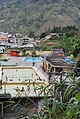
Thermal baths in Baños

Downtown Baños

Local residents (2009)
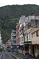
Baños de Agua Santa street

Street in Baños (2009)


References
^ Ecuadorian National Institute of Statistics and Census
^ Tungurahua on volcanodiscovery.com
^ Baños at pachamama.org
^ (in Spanish) Article on hoy.com.ec Archived April 9, 2009, at the Wayback Machine
^ Viva Travel Guides
^ ab www.banios.com
^
"Baños climate: Average temperature, weather by month, Baños averages: Climate-Data.org". en.climate-data.org. Retrieved 26 January 2019..mw-parser-output cite.citation{font-style:inherit}.mw-parser-output .citation q{quotes:"""""""'""'"}.mw-parser-output .citation .cs1-lock-free a{background:url("//upload.wikimedia.org/wikipedia/commons/thumb/6/65/Lock-green.svg/9px-Lock-green.svg.png")no-repeat;background-position:right .1em center}.mw-parser-output .citation .cs1-lock-limited a,.mw-parser-output .citation .cs1-lock-registration a{background:url("//upload.wikimedia.org/wikipedia/commons/thumb/d/d6/Lock-gray-alt-2.svg/9px-Lock-gray-alt-2.svg.png")no-repeat;background-position:right .1em center}.mw-parser-output .citation .cs1-lock-subscription a{background:url("//upload.wikimedia.org/wikipedia/commons/thumb/a/aa/Lock-red-alt-2.svg/9px-Lock-red-alt-2.svg.png")no-repeat;background-position:right .1em center}.mw-parser-output .cs1-subscription,.mw-parser-output .cs1-registration{color:#555}.mw-parser-output .cs1-subscription span,.mw-parser-output .cs1-registration span{border-bottom:1px dotted;cursor:help}.mw-parser-output .cs1-ws-icon a{background:url("//upload.wikimedia.org/wikipedia/commons/thumb/4/4c/Wikisource-logo.svg/12px-Wikisource-logo.svg.png")no-repeat;background-position:right .1em center}.mw-parser-output code.cs1-code{color:inherit;background:inherit;border:inherit;padding:inherit}.mw-parser-output .cs1-hidden-error{display:none;font-size:100%}.mw-parser-output .cs1-visible-error{font-size:100%}.mw-parser-output .cs1-maint{display:none;color:#33aa33;margin-left:0.3em}.mw-parser-output .cs1-subscription,.mw-parser-output .cs1-registration,.mw-parser-output .cs1-format{font-size:95%}.mw-parser-output .cs1-kern-left,.mw-parser-output .cs1-kern-wl-left{padding-left:0.2em}.mw-parser-output .cs1-kern-right,.mw-parser-output .cs1-kern-wl-right{padding-right:0.2em}
External links
| Wikimedia Commons has media related to Baños. |
- Baños-Ecuador Travel site
 Baños travel guide from Wikivoyage


