Cockroad Wood Castle
| Cockroad Wood Castle | |
|---|---|
| Charlton Musgrove, Somerset | |
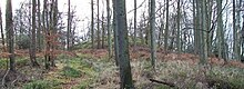 Motte of Cockroad Wood Castle | |
 Cockroad Wood Castle | |
| Coordinates | 51°05′15″N 2°21′50″W / 51.0876°N 2.3640°W / 51.0876; -2.3640Coordinates: 51°05′15″N 2°21′50″W / 51.0876°N 2.3640°W / 51.0876; -2.3640 |
| Grid reference | grid reference ST746321 |
| Type | Motte and bailey |
| Site information | |
| Condition | Earthworks remain |
Cockroad Wood Castle was a castle near Wincanton but now in the parish of Charlton Musgrove, Somerset, England.
Contents
1 History
2 See also
3 Bibliography
4 References
History
Cockroad Wood Castle was a motte and bailey castle, probably built after the Norman conquest of England in 1066.[1] The castle sits close to the contemporary Norman castles of Ballands and Castle Orchard, and may have been built a system of fortifications to control the surrounding area.[1] By 1086 the surrounding land was held by Walter of Douai, although no documentary evidence of the castle remains.[2]
The castle was built with a motte and two baileys, running along a north-south ridge, with a possible entrance to the east.[2] The motte today is 13.5m wide, up to 7.5m high and is surrounded by a 1.25m deep ditch.[2] The two baileys were probably linked to the motte by wooden bridges.[2]
Today the castle site is a scheduled monument.[3]
See also
- Castles in Great Britain and Ireland
- List of castles in England
Bibliography
- Creighton, Oliver Hamilton. (2005) Castles and Landscapes: Power, Community and Fortification in Medieval England. London: Equinox. .mw-parser-output cite.citation{font-style:inherit}.mw-parser-output .citation q{quotes:"""""""'""'"}.mw-parser-output .citation .cs1-lock-free a{background:url("//upload.wikimedia.org/wikipedia/commons/thumb/6/65/Lock-green.svg/9px-Lock-green.svg.png")no-repeat;background-position:right .1em center}.mw-parser-output .citation .cs1-lock-limited a,.mw-parser-output .citation .cs1-lock-registration a{background:url("//upload.wikimedia.org/wikipedia/commons/thumb/d/d6/Lock-gray-alt-2.svg/9px-Lock-gray-alt-2.svg.png")no-repeat;background-position:right .1em center}.mw-parser-output .citation .cs1-lock-subscription a{background:url("//upload.wikimedia.org/wikipedia/commons/thumb/a/aa/Lock-red-alt-2.svg/9px-Lock-red-alt-2.svg.png")no-repeat;background-position:right .1em center}.mw-parser-output .cs1-subscription,.mw-parser-output .cs1-registration{color:#555}.mw-parser-output .cs1-subscription span,.mw-parser-output .cs1-registration span{border-bottom:1px dotted;cursor:help}.mw-parser-output .cs1-ws-icon a{background:url("//upload.wikimedia.org/wikipedia/commons/thumb/4/4c/Wikisource-logo.svg/12px-Wikisource-logo.svg.png")no-repeat;background-position:right .1em center}.mw-parser-output code.cs1-code{color:inherit;background:inherit;border:inherit;padding:inherit}.mw-parser-output .cs1-hidden-error{display:none;font-size:100%}.mw-parser-output .cs1-visible-error{font-size:100%}.mw-parser-output .cs1-maint{display:none;color:#33aa33;margin-left:0.3em}.mw-parser-output .cs1-subscription,.mw-parser-output .cs1-registration,.mw-parser-output .cs1-format{font-size:95%}.mw-parser-output .cs1-kern-left,.mw-parser-output .cs1-kern-wl-left{padding-left:0.2em}.mw-parser-output .cs1-kern-right,.mw-parser-output .cs1-kern-wl-right{padding-right:0.2em}
ISBN 978-1-904768-67-8.
References
^ ab Creighton, p.62.
^ abcd Motte and Bailey Castle, Cockroad Wood, Charlton Musgrove, Somerset County Historic Environmental Record, accessed 18 July 2011.
^ Cockroad Wood Motte, Charlton Musgrove, Gatehouse website, accessed 18 July 2011.


