Eilean Sùbhainn
| Meaning of name | Possibly "island of berries"[1] |
|---|---|
| Location | |
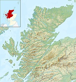  Eilean Sùbhainn Eilean Sùbhainn shown within Highland Scotland | |
| OS grid reference | NG923722 |
| Coordinates | 57°41′N 5°29′W / 57.69°N 5.48°W / 57.69; -5.48 |
| Physical geography | |
| Island group | Loch Maree |
| Area | 118 ha |
| Area rank | 141 (Freshwater: 2) [2] |
| Highest elevation | 36 m |
| Administration | |
| Sovereign state | United Kingdom |
| Country | Scotland |
| Council area | Highland |
| Demographics | |
| Population | 0[3] |
 | |
| References | [4] |
Eilean Sùbhainn is the largest of several small islands in Loch Maree, Wester Ross, Scotland. It is the second largest freshwater island in Scotland after Inchmurrin.

Lochan on Eilean Sùbhainn
Lying a mile (2 km) northeast of Talladale, the island is partially forested and uninhabited. It rises to 36m (118 feet) and extends to 118 ha (292 acres). The island is a nature reserve and includes several small lochans.[5][6]
Footnotes
^ "Place names C to E". Gordon C. Harrison. Retrieved 11 June 2012 - quoting Wentworth, R.G., (1998) Place-Names of Loch Maree Islands National Nature Reserve. Scottish Natural Heritage.
^ Area and population ranks: there are c. 300 islands over 20 ha in extent and 93 permanently inhabited islands were listed in the 2011 census.
^ General Register Office for Scotland (28 November 2003) Scotland's Census 2001 – Occasional Paper No 10: Statistics for Inhabited Islands. Retrieved 26 February 2012.
^ Ordnance Survey
^ "Overview of Eilean Subhainn". Gazetteer for Scotland. Retrieved 2007-12-14..mw-parser-output cite.citation{font-style:inherit}.mw-parser-output .citation q{quotes:"""""""'""'"}.mw-parser-output .citation .cs1-lock-free a{background:url("//upload.wikimedia.org/wikipedia/commons/thumb/6/65/Lock-green.svg/9px-Lock-green.svg.png")no-repeat;background-position:right .1em center}.mw-parser-output .citation .cs1-lock-limited a,.mw-parser-output .citation .cs1-lock-registration a{background:url("//upload.wikimedia.org/wikipedia/commons/thumb/d/d6/Lock-gray-alt-2.svg/9px-Lock-gray-alt-2.svg.png")no-repeat;background-position:right .1em center}.mw-parser-output .citation .cs1-lock-subscription a{background:url("//upload.wikimedia.org/wikipedia/commons/thumb/a/aa/Lock-red-alt-2.svg/9px-Lock-red-alt-2.svg.png")no-repeat;background-position:right .1em center}.mw-parser-output .cs1-subscription,.mw-parser-output .cs1-registration{color:#555}.mw-parser-output .cs1-subscription span,.mw-parser-output .cs1-registration span{border-bottom:1px dotted;cursor:help}.mw-parser-output .cs1-ws-icon a{background:url("//upload.wikimedia.org/wikipedia/commons/thumb/4/4c/Wikisource-logo.svg/12px-Wikisource-logo.svg.png")no-repeat;background-position:right .1em center}.mw-parser-output code.cs1-code{color:inherit;background:inherit;border:inherit;padding:inherit}.mw-parser-output .cs1-hidden-error{display:none;font-size:100%}.mw-parser-output .cs1-visible-error{font-size:100%}.mw-parser-output .cs1-maint{display:none;color:#33aa33;margin-left:0.3em}.mw-parser-output .cs1-subscription,.mw-parser-output .cs1-registration,.mw-parser-output .cs1-format{font-size:95%}.mw-parser-output .cs1-kern-left,.mw-parser-output .cs1-kern-wl-left{padding-left:0.2em}.mw-parser-output .cs1-kern-right,.mw-parser-output .cs1-kern-wl-right{padding-right:0.2em}
^ "Loch Maree Islands National Nature Reserve". Scottish Natural Heritage. Retrieved 2007-12-14.
 | Wikimedia Commons has media related to Eilean Sùbhainn. |
Islands of Scotland | |||||||||||||||||
|---|---|---|---|---|---|---|---|---|---|---|---|---|---|---|---|---|---|
|  | ||||||||||||||||
|
| |||||||||||||||||
| |||||||||||||||||
| |||||||||||||||||
| |||||||||||||||||
| |||||||||||||||||
| |||||||||||||||||
| |||||||||||||||||
Coordinates: 57°41.5′N 5°29′W / 57.6917°N 5.483°W / 57.6917; -5.483
 | This Highland location article is a stub. You can help Wikipedia by expanding it. |


